Step 2
Roots Report
The full village report. For families who know their ancestor's town or village and want its history, temples and records.
Download this sample as delivered (PDF, 1.8 MB)
Roots Report
The Ando families of Nagaiwaya 長岩屋の安東一族
The Ando name and the village of Nagaiwaya in the records
| Registered domicile | Nagaiwaya, Bungo-Takada City, Oita Prefecture |
|---|---|
| Formerly | Nagaiwaya, Nishi-Tomiku Village, Nishi-Kunisaki District |
| Edo period (1603–1868) | Nagaiwaya Village, Kunisaki District, Bungo Province (now Oita Prefecture) |
| Prepared for | [client name withheld] |
| Date | October 5, 2026 |
Sample. The family name and registered domicile are fictional; every place, record and source is real.
綴Koseki Roots
Dates. We write dates month first, as in the US, with the Japanese era year in parentheses: March 4, 1882 (Meiji 15). Dates before 1873 follow Japan's old lunar calendar and are given as in the source ("the 17th day of the 3rd month, 1580"). Lunar months ran 3–7 weeks behind Western months, so the "1st month" began in late January or February. About every three years an extra "intercalary" (leap) month was inserted: an "intercalary 3rd month" is a second 3rd month that followed the ordinary one. Japanese terms are explained in our glossary.
A two-minute guide to Japanese history for family historians
Why you need this. Your family's records were written by people who took for granted a world of provinces, domains, headmen and lunar months. This page gives you just enough of that world to follow the story. Terms are also explained in our glossary.
The periods you will meet
Historians divide Japan's past by who held power. For a family historian, five periods matter:
| Period | Years | What it means for your family |
|---|---|---|
| Heian | 794–1185 | Court nobles rule from Kyoto (the imperial capital). The oldest surnames and estate names date from here. |
| Kamakura | 1185–1333 | The first warrior government. Land registers and estate records begin naming local families. |
| Muromachi (1336–1573) and the Warring States period (Sengoku, c. 1467–1600) | 1336–1600 | Central power collapses, and regional warlords fight for territory. In Kyushu (Japan's southwestern main island) they include the Ōtomo (who ruled Bungo, today's Oita) and the Shimazu (who ruled southern Kyushu). Local land-holding families fight for them in return for land. Most documents in a Family Chronicle (our book-length family history) come from here. |
| Edo | 1603–1868 | Two and a half centuries of peace under the Tokugawa shoguns (hereditary military rulers of Japan). The country is divided into some 260 domains, each run by a hereditary lord (daimyo). Villages are taxed in rice and run by hereditary headmen. Every household must register with a Buddhist temple. Travel abroad and emigration are forbidden. |
| Meiji | 1868–1912 | The shogun falls and the emperor's government modernizes Japan. The family register (koseki) begins in 1872 (the 1872 registers are sealed; those from 1886 onward are open to descendants). Everyone must take a surname (1875); villages are merged into modern municipalities (1889); and emigration to Hawaii, North America and later Brazil begins (1885 onward). This is the Japan that your Issei ancestors knew. |
Province, domain, district, village
Before 1871 Japan was divided into about 70 provinces (Bungo is now Oita Prefecture), each divided into districts (gun) of many villages. Over them, in the Edo period, lay the domains — fiefs ruled by lords who taxed the villages inside them. Domains could own scattered pieces of land, which is how a village in Oita could belong to the lord of Shimabara in Nagasaki.
In 1871 provinces and domains were replaced by prefectures; in 1889 thousands of hamlets were grouped into the villages whose names your Issei ancestors wrote on ship manifests. Those villages have since merged, twice more, into today's towns and cities. That is why the office that holds your family's register may be in a city you have never heard of.
Who was who in a village
Each Edo-period village was run for its lord by a headman (shōya or nanushi), a hereditary post held by a leading farming family of the village. Some of these families descended from the local warriors of the wars of the Warring States period. Above the village stood the samurai, the lord's hereditary retainers and administrators, who — with a few privileged others — could officially use surnames and carry swords.
Below the headman were ordinary registered households. When the Meiji government required everyone to register a surname in 1875, families chose names: some long used unofficially, others taken from a place, a field or a leading local family. A shared surname therefore shows where to look, not whom you descend from.
Names
Japanese names are written surname first, as in Japan: YAMANE Seikichi is Mr. Yamane. In older records a man might also carry an everyday name, a formal name and a scholar's courtesy name (a second, Chinese-style name). He might also hold an honorary court-style title granted by his lord (Kunai-no-jō, Izumi-no-kami). The same man can appear under several of these; a Chronicle's index gathers them.
Dates
Japan counted years by imperial era (Meiji 15 = 1882). Until 1872 it also used a lunar calendar, whose months ran a few weeks behind ours and which gained an extra "intercalary" month every third year or so. Ages were "counted years": one at birth and another every New Year. We give Western years everywhere and note the original where it matters.
The records
From 1886 onward, the koseki records every birth, marriage, adoption and death in a household — but registers before that date are sealed by law. For the time before that we turn to the sources the Edo period produced. These are the temple's death register and memorial tablets, the village's religious census and the domain's land surveys; a few families also hold letters and land deeds handed down for centuries. Local histories compiled in the 1910s–30s (the "gazetteers" we cite) collected many of these.
A Roots Report tells you which of them exist for your village; a Family Chronicle works through what they say. They record the families of the name in the village; whether they are your own ancestors can seldom be shown.
The emigration years
Government-sponsored emigration to Hawaii began in 1885, mostly from Hiroshima, Yamaguchi, Kumamoto, Fukuoka and later Okinawa. The mainland US and Canada followed in the 1890s, Brazil from 1908. Emigrants stayed on their village register. That is why the koseki of a family that left in 1905 still sits in a city office in Japan, and why its address, the honseki (registered domicile), is the key to everything.
This report brings together what can be established before your family's koseki is examined. It covers how the Ando name is distributed, how Nagaiwaya and the Tomiku villages came to be, modern directories, likely family temples, the Edo-period village, medieval and Warring States records, and local traditions. It works back from the present into the past to frame the origins of the families of the name, so you can decide whether and how to research further.
At a glance
- Your family's registered domicile (honseki), Nagaiwaya, lies in the Kunisaki Peninsula of Oita Prefecture. Oita has more people named Ando than any other prefecture.
- At Sano, about 9 km (6 mi) away, families of the same name keep letters from 1580 and, by the gazetteer's account, served as village headmen through the Edo period (1603–1868).
- Your family may belong to this Ando line of the western Kunisaki Peninsula. This is our inference from distance and distribution, not a documented link.
- This report covers the surname, its village and the families of that name in the records; it does not prove your own line. Your koseki traces your line back to the 1870s–80s; before that, the family temple's death registers may help, if they survive. Section 12 explains how to request the koseki.
How to read this report. The wording follows the strength of the evidence. Where we state something plainly, it rests on documents written at the time. Where we write "according to the gazetteer," "is said" or "by tradition," it rests on histories compiled later or on local tradition. Words such as "likely," "may" and "possible" mark our own inferences, which further records may support or rule out.
1. The Ando name across Japan
At a glance
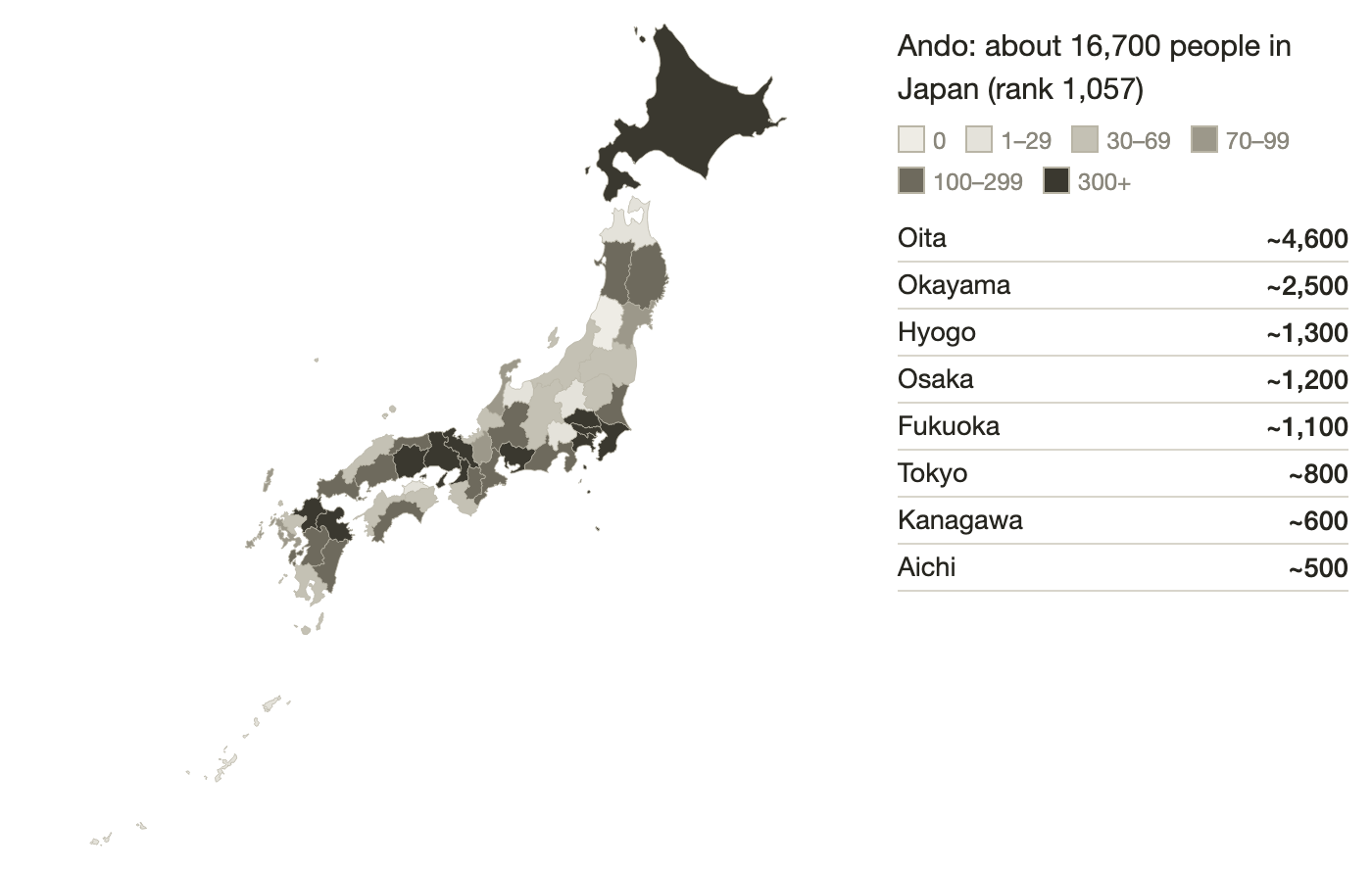
- About 16,700 people in Japan carry the surname Ando (安東).
- Oita Prefecture has the most, about 4,600.
- Bungo-Takada City, which includes your ancestral village, is one of the cities in Japan with the most Ando households.
About 16,700 people in Japan carry the surname Ando (安東), making it the 1,057th most common surname. (We write 安東 as "Ando" and the differently written 安藤 as "Andō" to keep them apart; they sound the same.) By prefecture, Oita has the most (about 4,600), followed by Okayama (2,500), Hyogo (1,300), Osaka (1,200) and Fukuoka (1,100).
By city, Oita City has the most in Japan (about 2,600), followed by Usuki City (900), Tsuyama and Okayama in Okayama Prefecture (about 400 each), and Bungo-Takada and Beppu (about 300 each). The name is concentrated in two places: Oita Prefecture, and the Mimasaka–Bizen area of Okayama Prefecture (the old Mimasaka and Bizen provinces). Bungo-Takada, which contains the ancestral village, is one of the cities in Japan with the most Ando households.
2. The Ando name in Oita Prefecture
At a glance
- About 300 Ando live in Bungo-Takada City.
- Most live in the Katsura River basin, about 5–10 km (3–6 mi) from the village.
- A few still live in Nagaiwaya itself and elsewhere in the Tomiku valley.
About 300 Ando live in Bungo-Takada City. Looking hamlet by hamlet, they cluster in the Katsura River basin in the south of the city: Kunawa (about 50; about 70 including Kunawa-Jōnan and Kunawa-Unbayashi), Sano (about 40), and Odawara, Miwa and Tadesu (about 30 each). There are Ando in Nagaiwaya itself, and also at Hitohata and Arao in the Tomiku valley.
| Hamlet | People (est.) | Notes |
|---|---|---|
| Nagaiwaya | very few | The hamlet of your registered domicile |
| Hitohata | ~10 | East side of the Tomiku valley, ~3.5 km (~2.2 mi) |
| Arao | very few | West side of the Tomiku valley, ~5.2 km (~3 mi) |
| Kunawa (incl. Kunawa-Jōnan, Kunawa-Unbayashi) | ~70 | Katsura River basin, ~10 km (~6 mi) |
| Sano (incl. Sano-Nishikawa-Maruyama) | ~40 | Katsura River basin; site of Kurakake (a castle besieged in 1580; section 8), named in letters of 1580; ~9.4 km (~6 mi) |
| Odawara | ~30 | ~6.6 km (~4 mi) |
| Miwa | ~30 | ~8.1 km (~5 mi) |
| Tadesu | ~30 | Part of Tashibu, ~4.6 km (~2.9 mi) |
| Takada-Nishishin, Takada-Korenaga | ~10 | City center, ~10 km (~6 mi) |
Across Oita Prefecture the Ando form four clusters: Bungo-Takada, about 9 km (6 mi) in a straight line from the village; Oita City, 38 km (24 mi); Usuki, 55 km (34 mi); and Ōno, 60 km (37 mi). Nagaiwaya sits at the eastern edge of the Bungo-Takada cluster in the western Kunisaki Peninsula.
3. Ando households around the ancestral village
At a glance
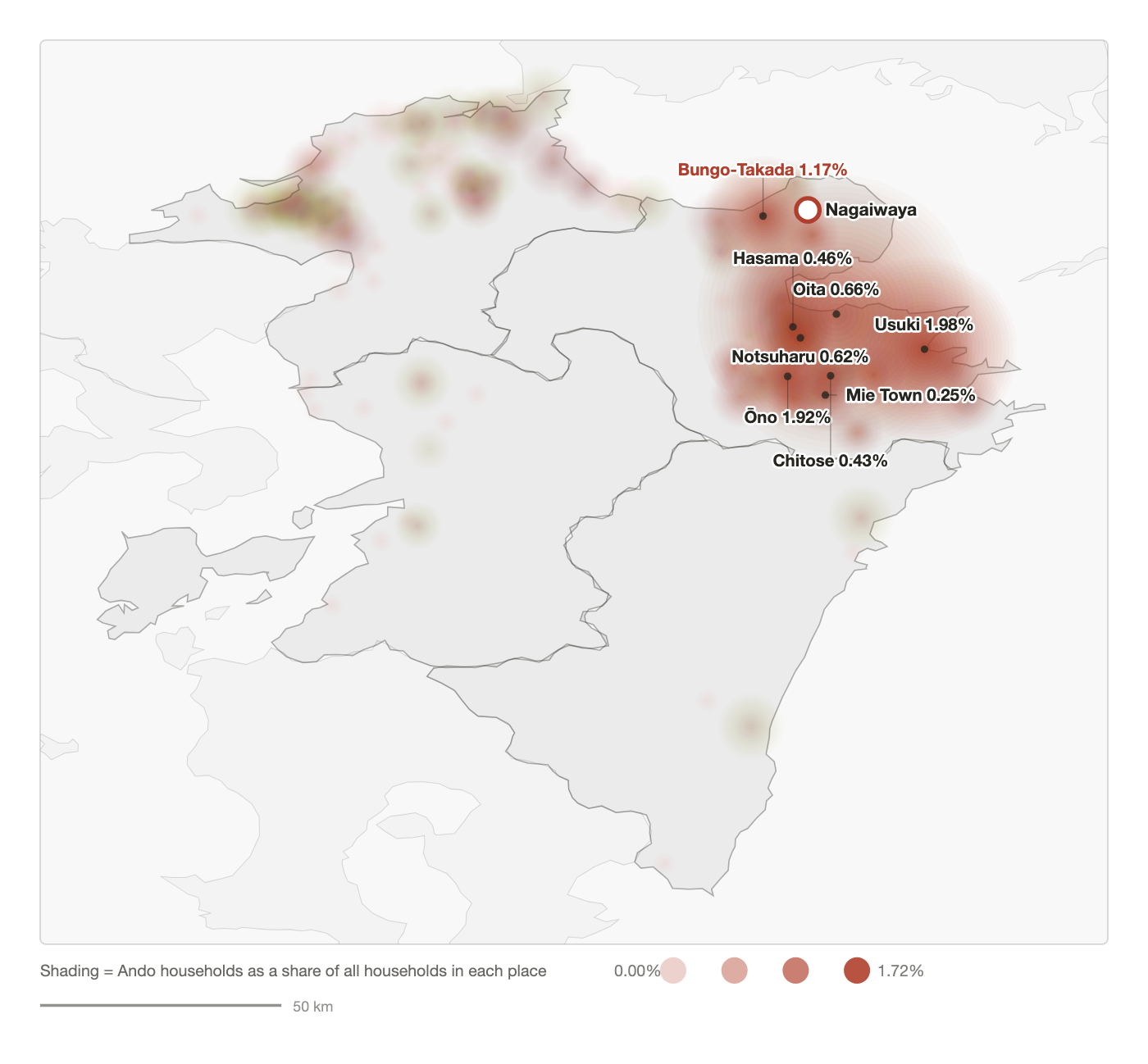
- By share of households, the name is densest in Usuki (1.98%) and Ōno (1.92%), 55–60 km (34–37 mi) to the south.
- Bungo-Takada comes next (1.17%), only about 9 km (6 mi) from the village.
- Our assessment centers on the western Kunisaki Peninsula, where old families of the name still live.
Below, every place where the Ando name appears is plotted by its distance from Nagaiwaya and by the share of its households that are Ando. Because surnames do not stop at prefectural borders, Oita and the neighboring prefectures of Fukuoka, Kumamoto and Miyazaki are shown together. We show municipalities as they were before the mergers of the 2000s, because those boundaries are one step closer to Edo-period villages.
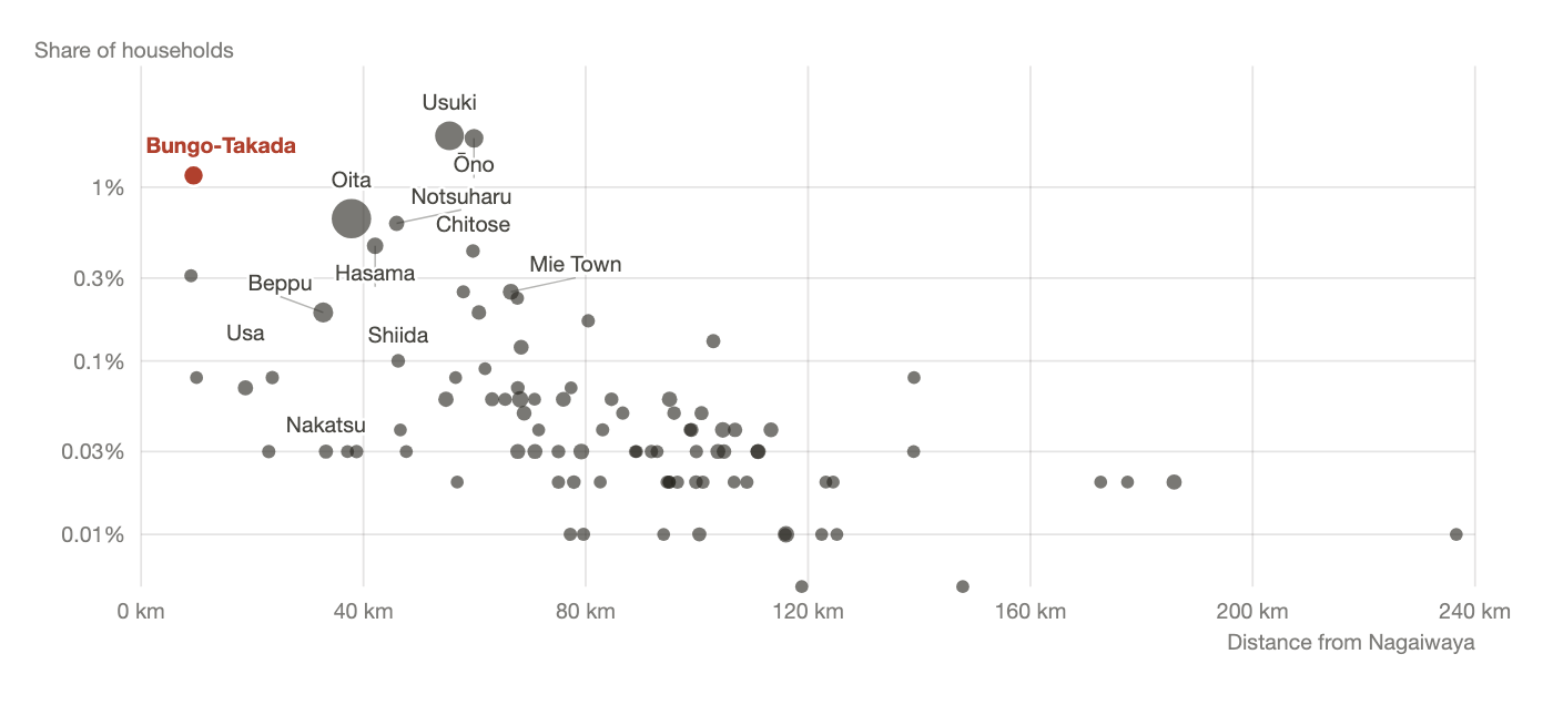
The highest shares are in the south: Usuki City, 55 km (34 mi) away (1.98%, 192 households), and Ōno Town, 60 km (37 mi) away (1.92%, 34 households). Bungo-Takada, home of the ancestral village, comes next at 1.17% (60 households), and its center is only about 9 km (6 mi) away.
Oita City has the most households (512) but ranks fourth by share (0.66%). Nearby Ota Village, 9 km (6 mi) away, also ranks among the top places by share (0.31%, 2 households). In Fukuoka, Kumamoto and Miyazaki the share is 0.13% or less everywhere. The Ando of Oita form two zones: Bungo-Takada in the western Kunisaki Peninsula, and Usuki–Ōno–Oita in the south.
| Municipality (as of 2000) | Ando households | All households | Share | Distance |
|---|---|---|---|---|
| Usuki City | 192 | 9,697 | 1.98% | 55 km (34 mi) |
| Ōno Town | 34 | 1,771 | 1.92% | 60 km (37 mi) |
| Bungo-Takada City | 60 | 5,128 | 1.17% | 9 km (6 mi) |
| Oita City | 512 | 77,576 | 0.66% | 38 km (24 mi) |
| Notsuharu Town | 9 | 1,452 | 0.62% | 46 km (29 mi) |
| Hasama Town | 15 | 3,261 | 0.46% | 42 km (26 mi) |
| Chitose Village | 3 | 698 | 0.43% | 60 km (37 mi) |
| Ota Village | 2 | 645 | 0.31% | 9 km (6 mi) |
How to interpret the Ando of Usuki and Ōno
Usuki and Ōno, 55–60 km (34–37 mi) away, are where the name is densest today. There are two possible readings. One is that, while the whole of Bungo Province was ruled by the Ōtomo, people of the same name moved freely within it. A family moving 55 km (34 mi) over 400 years is entirely plausible.
The other is that the south has its own, separate origin. A medieval holding called "Andō-myō" (myō: a medieval unit of taxable fields) is identified by the editor of a source collection as a place in Ōno (see sections 8 and 10).
Tracing the family's Edo-period residence through the koseki and village documents may show which reading is right. Our assessment centers on the western Kunisaki Peninsula, 9 km (6 mi) from the village, where old families of the name still live.
4. Nagaiwaya and the Tomiku valley through time
At a glance
- Nagaiwaya lay within the Tomiku estate, a medieval landholding recorded in a land register of 1285.
- In the Edo period it belonged to the Shimabara domain, a territory ruled by a hereditary lord.
- Since 1954 it has been part of Bungo-Takada City.
Nagaiwaya lies in the center of the Kunisaki Peninsula, in the valley of the upper Tomiku River, which flows west from Mount Futago. The Nishi-Kunisaki Gunshi (the district gazetteer, a local encyclopedia compiled in 1923) describes a gorge about 4 km (2.5 mi) long, lined with cliffs hundreds of feet high. The gorge was known as "Tomiku-yaba" (yaba: a gorge of towering rock formations; the word comes from the famous Yabakei gorge). The gazetteer notes that the valley road led on to Kami-Imi Village in Higashi-Kunisaki. The Tomiku River runs through Nagaiwaya to Matsuyuki, joins the stream from Hitohata, and flows down to Takada. 6
| Year | Event | Source |
|---|---|---|
| 1285 | The Bungo Province land register lists the Tomiku estate in Kunisaki District as a holding of Usa Mirokuji, the Buddhist temple attached to the great Usa Shrine. The estate (shōen: a medieval landholding owned by a temple or noble and worked by local families) measured 70 chō (about 70 hectares, or 170 acres). The land steward (jitō: the warrior appointed to police and tax the estate) is Tomiku Saemon Nyūdō Saigei 都甲左衛門入道西迎. Saemon is an honorary court-style title, part of the name. Nyūdō marks a warrior who had taken Buddhist vows. His son Gorō Saemon Korechika 五郎左衛門惟近 succeeds him. | Later compilation |
| Edo period (1603–1868) | Nagaiwaya Village is part of the Shimabara domain (Matsudaira clan) — one of some 260 domains ruled by hereditary lords (daimyo) under the shogun. Shimabara's castle was in today's Nagasaki Prefecture; this corner of Kunisaki was one of its detached holdings. A register of the Rokugō Manzan temples from the 1780s lists the temple Tennenji of Nagaiwaya Village as "Shimabara territory." Rokugō Manzan is the temple network of the Kunisaki Peninsula (see section 6), of the Tendai school, one of Japan's major Buddhist schools. | Later compilation |
| 1803 | The Bungo Kokushi (a gazetteer of Bungo Province) names nine villages, including Nagaiwaya, Kaneigawa and Hitohata, as formerly belonging to the Tomiku estate. | Later compilation |
| 1875 | Ten villages of the old estate, including Nagaiwaya, are combined as Tomiku Village, with its office at Matsuyuki. | Later compilation |
| 1884 | A branch school opens in Nagaiwaya. Five villages, including Nagaiwaya, form a union with a village office at Tsukiji. | Later compilation |
| 1889 | Under the new municipal system the five villages merge as Nishi-Tomiku Village, with Nagaiwaya as one of its areas. | Later compilation |
| 1951–54 | In 1951 Nishi-Tomiku Village merges into Takada Town, which becomes Bungo-Takada City on May 31, 1954. | City publication |
| 1977 | The Kunisaki Shujō Onie, a New Year fire festival, is designated an Important Intangible Folk Cultural Property of Japan; the Nagaiwaya preservation society is one of its custodians. | National heritage record |
| 2017 | The Tennenji-yaba and Mudōji-yaba cliffs are designated a National Place of Scenic Beauty. | National heritage record |
5. Modern directories and registers
At a glance
- Directories from 1882 to 1932 list Ando near the village and in Usuki.
- None list an Ando in Nishi-Tomiku Village, which included Nagaiwaya, from 1889 to 1923.
- A mayor of the neighboring village wrote the name 安藤 (Andō). The closed registers may show which spelling your family used.
The directories and gazetteers below, from the Meiji era (1868–1912) to the early Shōwa era (1926–1989), list Ando entries near the village and across Oita.
| Year | Source | Entry |
|---|---|---|
| 1882 | District record (printed) | Ando Kyūka 安東九華, head of Nishi-Kunisaki District; registered domicile Kawachi Village, ~9 km (~6 mi) from Nagaiwaya. |
| 1889–1923 | District record (printed) | No Ando entries for Nishi-Tomiku Village. |
| 1918–1923 | District record (printed) | In Higashi-Tomiku Village, immediately east of Nagaiwaya (Kaneigawa is ~1.3 km, or ~0.8 mi, away), Andō Kamematsu 安藤亀松 serves as village mayor from August 1918 and also heads the youth association. The gazetteer spells the name 安藤. |
| 1928 | Company directory | Ando Shinpei 安東新平 of Usuki Town, auditor of Nippon Mitsumata Mining. |
| 1931 | Company directory | Ando Kyūbei 安東久兵衛 of Usuki Town. |
| 1932 | Company directory | Ando Masao 安東正夫 of Takada Town, Nishi-Kunisaki, ~10 km (~6 mi) away. |
The places where Ando appear in these directories — Kawachi and Takada (now Bungo-Takada) and Usuki — match the two areas where the name is densest today. In neighboring Higashi-Tomiku a village mayor wrote the name as 安藤. Whether the Ando of Nagaiwaya were written 安東 or 安藤 may become clear from the closed registers (older koseki no longer in use). 7
6. Likely family temples
At a glance
- The nearest temple is Tennenji, in Nagaiwaya itself, of the Tendai school of Buddhism.
- Eight temples within 9 km (6 mi) are listed below. All are candidates.
- The main family in Japan or the memorial tablets (ihai, kept on the family altar) may show which one was your family's temple.
Kunisaki's temples belong to Rokugō Manzan, a network of Tendai Buddhist mountain temples unique to the peninsula and recorded since the 8th century. Tendai is one of Japan's major Buddhist schools. The Rokugō temples were grouped into three ranks; a "middle mountain" temple is one of the second rank.
The table lists the temples within 9 km (6 mi) of Nagaiwaya (-ji at the end of a name means "temple"). All are candidates; the family's actual temple should be confirmed through the main family or its memorial tablets.
| Temple (mountain name) | Sect | Distance | Notes |
|---|---|---|---|
| Tennenji (Nagaiwaya-san) | Tendai | 0.6 km (0.4 mi) | In Nagaiwaya. A "middle mountain" temple of Rokugō; holds the New Year Shujō Onie. |
| Chōanji (Kongō-san) | Tendai | 0.9 km (0.6 mi) | On the slope of Mount Yayama; the gazetteer notes gorintō (five-tiered stone stupas used as grave and memorial markers) linked to the Yoshihiro family nearby (local warriors, a branch of the Ōtomo; see section 8). |
| Fukiji | 4.5 km (2.8 mi) | Tashibu-Tadesu | |
| Futagoji | 5.3 km (3 mi) | Mount Futago | |
| Mankōji | 6.9 km (4 mi) | ||
| Kōsanji (Saieizan) | Tendai | 8.1 km (5 mi) | A Rokugō temple |
| Iwatoji | 8.3 km (5 mi) | Temple with a Shujō Onie preservation society | |
| Maki Ōdō | 8.7 km (5 mi) | Tashibu-Manaka |
Many temples of the Rokugō Manzan tradition survive on the Kunisaki Peninsula. Nagaiwaya is the village in front of the gate of Tennenji, a "middle mountain" temple. The family temple of a Nagaiwaya household is most likely Tennenji or another temple in the Tomiku valley. 8
7. The Edo-period village and family
At a glance
- Nagaiwaya Village was land of the Shimabara domain, and its temple was Tennenji.
- At Sano, about 9 km (6 mi) away, an Ando family served as village headmen (shōya) through the Edo period, according to the gazetteer.
- The Sano Ando married into scholarly families.
- Temple death registers (kakochō) may show where the Nagaiwaya Ando lived in the Edo period.
Nagaiwaya Village was Shimabara domain land, and its temple was Tennenji. Elsewhere in Nishi-Kunisaki lies Sano, in Kawachi Village, about 9 km (6 mi) away (9.4 km, or 5.8 mi, in a straight line). There the gazetteer records an Ando family serving as village headmen (shōya) through the Edo period.
| Item | Content | Source |
|---|---|---|
| Lord | Nagaiwaya Village belonged to the Shimabara domain (Matsudaira clan). | Later compilation |
| Village temple | A Rokugō temple register of the 1780s records Tennenji as a branch temple. Its main hall is dedicated to Kannon (the bodhisattva of compassion) and the Six Gongen (local gods seen as forms of Buddhas). Its land is assessed at 5 koku and 8 to (a koku is about 180 liters, or 5 bushels, of rice; one to is a tenth of a koku). Its temple woods are 100 ken square (a ken is about 1.8 m, so about 180 m, or 600 ft, on each side). | Later compilation |
| Road | A road ran through Nagaiwaya to Akane Village in Higashi-Kunisaki. | Later compilation |
| 1786 | Miura Baien 三浦梅園, one of Edo Japan's most original philosophers, born in Kunisaki, writes to his son-in-law Ando Teigorō 安東貞五郎. Teigorō is the husband of Baien's eldest daughter Ruiko 類子. The letter tells of Baien being summoned by the lord of the neighboring Kitsuki domain. | Later compilation |
| 18th c. | The epitaph of Soyano Genpo 征矢野元甫, physician of the Nakatsu domain, records that his elder sister married into "the Ando of Bungo." | Later compilation |
| 1825 | Ando Kyūka 安東九華 (formal given name Sōmei 宗明; everyday name Teigorō 貞五郎) is born into the Sano family. He studies under Hoashi Banri 帆足万里, a leading scholar of the day who also taught Western science, and inherits the post of headman. He becomes ward head in 1875, under the short-lived ward system of the 1870s, and Nishi-Kunisaki District head in 1882. In 1890 he becomes a member of the House of Representatives of the Imperial Diet, Japan's first national parliament. | Later compilation |
| 1832 | Kōno Michinori 河野通卿, born into the Ando family of Sano in 1832, is adopted into the Kōno family of Tashibu and becomes its senior headman. | Later compilation |
| c. 1832 | Tanomura Chikuden 田能村竹田, a celebrated literati painter of Bungo, stays with an Ando family in Oita and completes a painting titled Kōbanzu (考盤図). | Later compilation |
| 1861–1864 | Ando Teisai 安東貞斎 of Kawachi Village experiments with treadle silk-reeling. | Later compilation |
According to the gazetteer, the Ando of Sano were headmen through the Edo period, and they married into scholarly families. Ties like these suggest that the Sano Ando ranked among the educated village elite. The everyday name "Teigorō" (貞五郎) appears in two generations, in the 1780s and the 1820s. The Shimabara domain's religious census registers (shūmon aratame-chō) and the death registers (kakochō) of Tennenji and other temples may show which village the Nagaiwaya Ando lived in during the Edo period. 7
8. Medieval and Warring States records
Who were the Ōtomo?
The Ōtomo were the warlords who ruled Bungo Province (today's Oita Prefecture) and, at their height, much of northern Kyushu, for some 400 years until 1593. Local land-holding families of Kunisaki fought for them in return for land, and their retainers appear throughout Kunisaki records. Their most famous head, Ōtomo Sōrin (大友宗麟, 1530–1587), a convert to Christianity, ruled Bungo in the Warring States period. His sons Ōtomo Yoshimune (大友義統) and Ōtomo Chikaie (大友親家) wrote most of the letters cited below.
Names such as Kunai-no-jō or Daizen-no-suke are honorary court-style titles granted or approved by a lord, not real offices; treat them as part of the name. See the glossary.
At a glance
- Nagaiwaya lay in the medieval Tomiku estate, at the foot of a castle of the Yoshihiro, a branch of the Ōtomo.
- In 1580, Ando Kunai-no-jō (安東宮内丞) fought for the Ōtomo at Kurakake Castle, about 9 km (6 mi) away. Letters written at the time record this.
- The gazetteer's Ando Shigekage (安東鎮景) is very likely the same man.
This section presents medieval (Kamakura, 1185–1333; Muromachi, 1336–1573) and Warring States records for the area around the village and for places linked to the Ando name, arranged by place. "Assessment" is our current view of how each record might connect to your family.
Tomiku estate (which included Nagaiwaya)
- People
- Land steward Tomiku Saemon Nyūdō Saigei 都甲左衛門入道西迎; his son Gorō Saemon Korechika 五郎左衛門惟近
- Record
- The 1285 land register lists the 70-chō Tomiku estate as a Usa Mirokuji holding, and says Korechika (惟近) succeeded his father as steward. The gazetteer adds that a Korechika of the Ōga lineage (an old warrior lineage of Bungo) appears in the clan registers of Ōtomo retainers, but notes that his place in the Ōga genealogy is not clear.
- Source
- Nishi-Kunisaki Gunshi, ch. 1 (citing the 1285 land register and the Bungo Kokushi)
- Distance
- 0 km (the estate itself)
- Assessment
- Nagaiwaya lay within the medieval Tomiku estate. A namesake of Korechika, the steward's son and successor, appears as an Ōga-lineage retainer of the Ōtomo, and the gazetteer names the Ōga as the Ando's ancestors. Whether the two are the same person remains a possibility noted by the gazetteer, not a fact.
Tennenji, Nagaiwaya (Rokugō Manzan)
- Record
- The catalog of Rokugō practices (a list of the rites performed at each Rokugō temple) lists Nagaiwaya under the "middle mountains." The New Year Shujō rite is performed for three nights, from the 4th to the 6th of the first month (lunar calendar; about February). A prayer list of 1284 against the Mongol invasions of Japan (1274, 1281) records Nagaiwaya performing seven days of Fudō rites (Fudō: a fierce guardian deity of Buddhism). A Rokugō document of 1338 assigns the sixth month (lunar; about July) of the mountain's ritual duties to Nagaiwaya.
- Source
- Nishi-Kunisaki Gunshi, ch. 14, "Ancient temples of Rokugō Manzan"
- Distance
- ~0.6 km (~0.4 mi)
- Assessment
- Nagaiwaya has been recorded as one of the Rokugō temple communities since the Kamakura period.
Yayama castle on Mount Yayama (Yoshihiro family)
- People
- Yoshihiro Uneme 吉弘采女 (by tradition), Yoshihiro Akimasa 吉弘鑑理, Yoshihiro Muneyuki 吉弘統幸
- Record
- Citing a local history, the gazetteer says Yoshihiro Uneme (吉弘采女) built Kakei castle (筧城) at Nagaiwaya in the years 1528–1532 and held Tomiku and Kami-Matama villages. The editor notes that Uneme does not appear in the Yoshihiro genealogies and dates the castle well before that era. The Yoshihiro genealogy in the same chapter names Akimasa (鑑理) and Muneyuki (統幸) as lords of the castle. The gazetteer's entry on the castle ruin on Mount Yayama identifies it with Kakei castle; we call it Yayama castle in this report.
- Source
- Nishi-Kunisaki Gunshi, ch. 6, "The Yoshihiro family"
- Distance
- ~1–2 km (0.6–1.2 mi)
- Assessment
- In the Warring States period the village lay at the foot of a castle of the Yoshihiro, a branch of the Ōtomo.
Sano: the Battle of Kurakake Castle
- People
- Ando Kunai-no-jō 安東宮内丞, Ando Daizen-no-suke 安東大膳亮, Ando Geki 安東外記
- Record
- Nine letters survive from the 1580 campaign against Tawara Chikatsura (田原親貫), who rebelled against the Ōtomo and held Kurakake Castle. Ōtomo Chikaie (大友親家), Tawara Jōnin (田原紹忍) and Ōtomo Yoshimune (大友義統) wrote them. They are addressed to Ando Kunai-no-jō (安東宮内丞), Maruyama Geki-no-jō (丸山外記丞), Ando Daizen-no-suke (安東大膳亮), Ando Geki (安東外記), Koreyasu Tatewaki-no-suke (是安帯刀亮) and the league of the district (a local alliance of warrior families). Kunai-no-jō, a local warrior on the Ōtomo side, joined the siege and was wounded in the intercalary (leap) 3rd month of 1580 (lunar calendar; about May). The letters show he held an estate assessed at 100 kan (a measure of a fief's value in coin) and was obliged to supply laborers.
- Source
- Nishi-Kunisaki Gunshi, ch. 29, "Old documents" (held by two families in Takada, one of them in Tamatsu)
- Distance
- ~9.4 km (~6 mi)
- Assessment
- Contemporary letters record that a man of the same surname fought 9 km (6 mi) from the village. The Nagaiwaya Ando may descend from his line; this is not a documented link.
The Ando family of Sano (gazetteer, biographies)
- People
- Ando Kunai-shōyū Shigekage 安東宮内少輔鎮景 (14th generation) and his brother Munesada 統貞
- Record
- The biographies chapter traces the family of Ando Kyūka (安東九華) to Ōga Koremoto (大神惟基) and says they served the Ōtomo for generations. In 1580 Shigekage (鎮景) and Munesada (統貞) attacked Tawara Chikatsura (田原親貫) and were granted Sano, where their descendants remained.
- Source
- Nishi-Kunisaki Gunshi, ch. 26, Biographies 9
- Distance
- ~9.4 km (~6 mi)
- Assessment
- Kunai-shōyū is a different title from Kunai-no-jō, one grade higher in the same court-style series. The Kunai-no-jō (宮内丞) of the letters and the Shigekage of the gazetteer both hold a Kunai title and fought at Kurakake in 1580; they are very likely the same man.
Andō Village, Ōno District
- Record
- The land register's entry "Andō-myō, 6 chō 6 tan" (a tan is one-tenth of a chō; about 6.5 hectares, or 16 acres) is annotated by the editor as Andō Village, Ōno District — today Andō in Ōno Town, Bungo-Ōno City.
- Source
- Zōho Teisei Hennen Ōtomo Shiryō (1942; a published collection of historical documents on the Ōtomo, arranged by date), note to the Bungo land register
- Distance
- ~53 km (~33 mi)
- Assessment
- The name Andō (Ando) appears as a Kamakura-period place name. Ōno today has the second-highest share of the Ando surname in Oita.
9. Local traditions
At a glance
- These traditions are local memory. They do not show your family's line.
- The gazetteer says the Ando of Bungo descend from the Ōga lineage, an old warrior lineage of Bungo.
- Tennenji's New Year fire festival, the Shujō Onie, is still held.
Traditions handed down in the area. They do not show your family's line; they are recorded here as local memory.
| Place | Tradition | Distance |
|---|---|---|
| Mount Yayama / Yayama castle | Yoshihiro Muneyuki 吉弘統幸 was killed at the Battle of Ishigakibaru (fought in Bungo in 1600, the year of Sekigahara, the battle that put the Tokugawa in power). Afterward, troops of Kuroda Jōsui 黒田如水 attacked his retainers holding Yayama castle. Kuroda Jōsui was a lord of northern Kyushu who fought on the Tokugawa side. Muneyuki's wife is said to have armed herself and fought at the castle. The rock from which she fell is called "Himeotoshi" ("Princess Drop"). | 1–2 km (0.6–1.2 mi) |
| Nagaiwaya (Tennenji) | The New Year Shujō Onie fire festival is said to bring good fortune and drive away misfortune through the performances of dancers dressed as demons. | 0.6 km (0.4 mi) |
| The Ando surname | The gazetteer's biographies say the Ando of Bungo descend from the Ōga lineage. | — |
| Andō (Ōno Town) | Identified with "Andō-myō" in the medieval land register. | ~53 km (~33 mi) |
10. Where did the Ando of this area come from?
At a glance
- Two places are recorded as origins of the name: the Ōga lineage, an old warrior lineage of Bungo (~68 km, or ~42 mi), and Andō Village in Ōno (~53 km, or ~33 mi).
- Takada and Sano, about 9 km (6 mi) away, are by far the closest. Warring States letters, Edo-period headmen and today's Ando households all meet there.
- None of these places is linked to your family by documents.
Two places are recorded as origins of the Ando. One is the Ōga lineage, which the gazetteer names as the ancestors of the Sano Ando. The other is Andō Village in Ōno District, which appears in the medieval land register. Both may connect to your family.
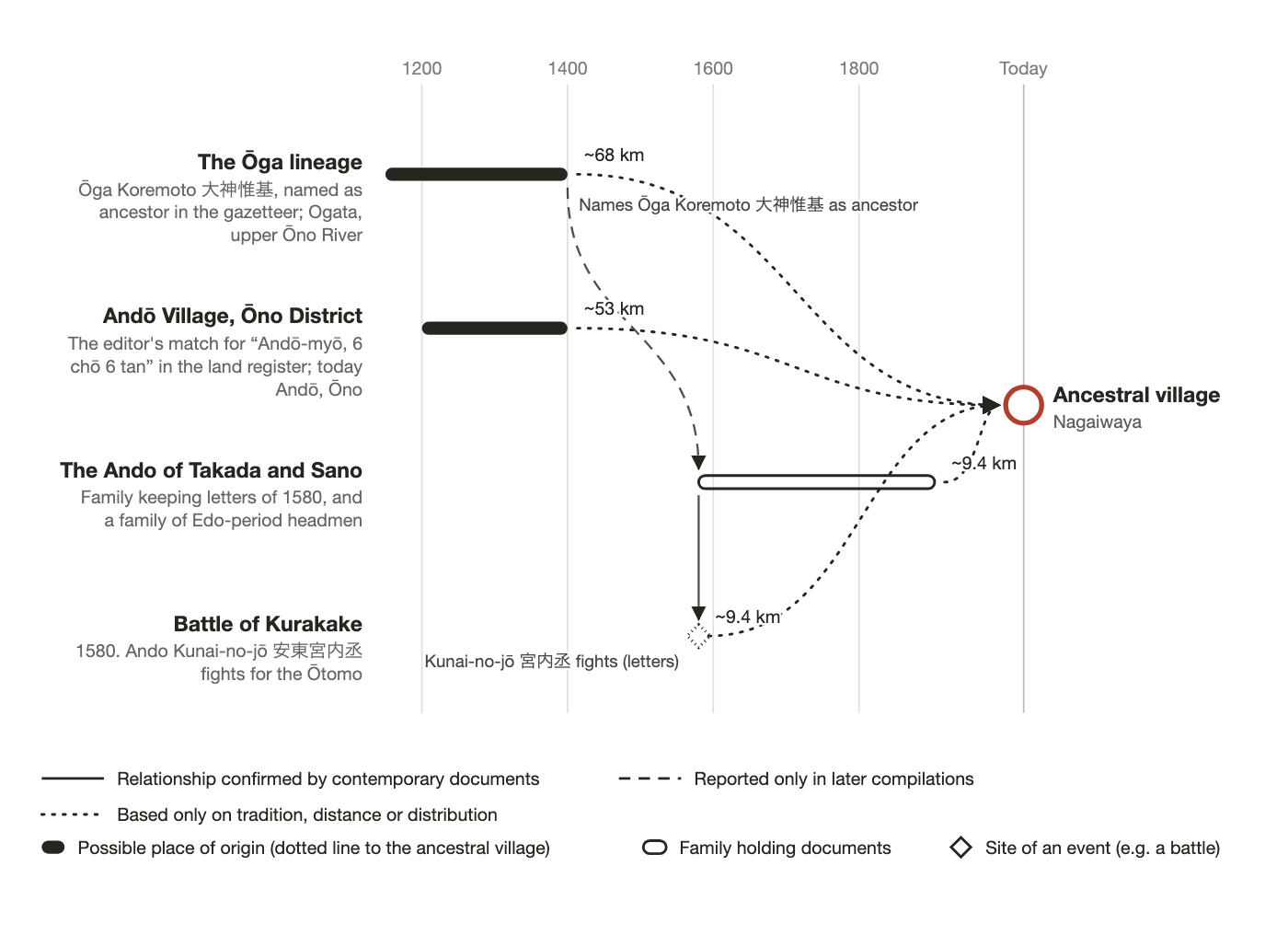
And at Takada and Sano, 9 km (6 mi) away, families of the same name keep the letters of 1580 and served as Edo-period headmen. The figure below places these three, and the Battle of Kurakake, on a timeline.
The Ōga lineage (Ogata, Bungo-Ōno City) — possible place of origin
- Evidence
- The gazetteer's biographies name Ōga Koremoto (大神惟基) as the ancestor of the Sano Ando. In Figure 4 we show Ogata, on the upper Ōno River, as the land associated with the Ōga lineage.
- Source
- Nishi-Kunisaki Gunshi, Biographies 9 (later compilation)
- Period
- Late Heian to Kamakura
- Distance
- ~68 km (~42 mi)
- Assessment
- The gazetteer notes that the registers of Ōtomo retainers list a Korechika of the Ōga lineage, with the same name as Korechika (惟近), the Tomiku estate's steward. Both the Tomiku estate's steward and the Ando's ancestor are linked to the Ōga name, so the Ando of this area may belong to this line. Whether yours does is not a documented link; we draw it as a dotted line.
Andō Village, Ōno District (Andō, Ōno Town) — possible place of origin
- Evidence
- Identified with "Andō-myō, 6 chō 6 tan" (about 6.5 hectares, or 16 acres) in the land register. Ōno still has the second-highest share of the Ando name in Oita (1.92%).
- Source
- Zōho Teisei Hennen Ōtomo Shiryō (editor's identification)
- Period
- Kamakura
- Distance
- ~53 km (~33 mi)
- Assessment
- Place name and surname match. The Ando of this area may come from this line.
The Ando of Takada and Sano (Bungo-Takada City) — families holding documents
- Evidence
- Two families in Takada (one of them in Tamatsu) keep the letters addressed to Ando Kunai-no-jō (安東宮内丞), who fought for the Ōtomo at Kurakake in 1580. The gazetteer calls the Sano family descendants of Shigekage (鎮景); that family served as Edo-period headmen.
- Source
- Nishi-Kunisaki Gunshi, ch. 29 (transcriptions of contemporary letters) and Biographies 9 (later compilation)
- Period
- 1580 to the Meiji era
- Distance
- ~9.4 km (~6 mi)
- Assessment
- Close enough for people to move back and forth in the Edo period. The Nagaiwaya Ando may belong to this line. If the family temple's death registers survive and can be seen, the names of Edo-period heads could be compared.
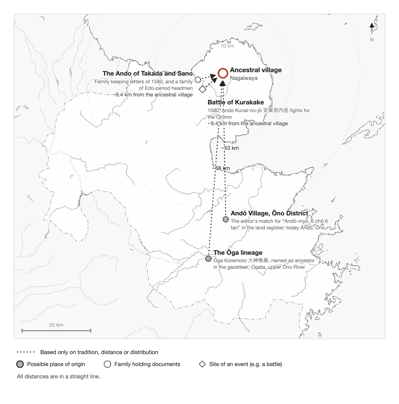
Of the three, Takada and Sano, 9 km (6 mi) away, are by far the closest. Warring States letters, Edo-period headmen and today's hamlet-level distribution all overlap there. The Ōga lineage and Andō Village are origins reported for the period before the Ando line reached Takada and Sano.
11. Summary
Your family's registered domicile is Nagaiwaya, deep in the Kunisaki Peninsula, in front of the gate of the Rokugō temple Tennenji. Ando is most common in Oita Prefecture. At Takada and Sano, 9 km (6 mi) away, a family of the same name keeps letters from 1580 and served as Edo-period headmen. It is possible that the Ando of Nagaiwaya belong to the Ando line rooted in the western Kunisaki Peninsula. The koseki reaches back only to the 1870s–80s; before that, temple records may help, if they survive.
- About 16,700 people bear the name nationwide; Oita has the most (about 4,600). Within the prefecture the share is highest in Usuki (1.98%), Ōno (1.92%) and Bungo-Takada (1.17%), whose center is 9 km (6 mi) from the village.
- Bungo-Takada's roughly 300 Ando cluster in the Katsura River basin (Kunawa, Sano, Odawara, Miwa, Tadesu), and also live in Nagaiwaya and at Hitohata and Arao in the Tomiku valley.
- Nagaiwaya has been recorded as a Rokugō temple community since the Kamakura period; it lay in the medieval Tomiku estate and was Nagaiwaya Village of the Shimabara domain in the Edo period. Since 1889 it has been part of Nishi-Tomiku Village (now Bungo-Takada).
- Two places are recorded as origins of the Ando of this area: the Ōga lineage (Ogata, ~68 km, or ~42 mi) and Andō Village in Ōno (~53 km, or ~33 mi). Either could lie behind your line; neither is a documented link.
- At Sano, 9 km (6 mi) away, Ando Kunai-no-jō (安東宮内丞) fought for the Ōtomo at Kurakake in 1580. Nine letters from this campaign survive in two families in Takada (one of them in Tamatsu). They are addressed to Kunai-no-jō, Maruyama Geki-no-jō (丸山外記丞), Ando Daizen-no-suke (安東大膳亮), Ando Geki (安東外記), Koreyasu Tatewaki-no-suke (是安帯刀亮) and the league of the district. The gazetteer says the Sano Ando descend from Ōga Koremoto (大神惟基) and that Kunai-shōyū Shigekage (宮内少輔鎮景) received Sano. By the gazetteer's account the family remained headmen through the Edo period. It produced Ando Teigorō (安東貞五郎), son-in-law of the philosopher Miura Baien (三浦梅園) and named in a letter of 1786, and Ando Kyūka (安東九華, born 1825).
- How far back you can expect to go: the koseki goes back to the registers of 1886; earlier ones are sealed by law. For the Edo period, the clues are Nagaiwaya's religious census registers and the death registers of Tennenji and other temples. For the Warring States period, nine letters survive in two families in Takada (one of them in Tamatsu), 9 km (6 mi) away.
The Kurakake letters are reliable contemporary records. The Sano Ando's ancestry comes from the later-compiled gazetteer. The Ōga lineage and Andō Village rest on tradition and place names.
On present evidence, the most likely reading has two parts. First, the Ando of this area descend from the Ando who fought for the Ōtomo in Kunisaki in the Warring States period and served as headmen at Sano in the Edo period. Second, the branch that lived at Nagaiwaya, among the Rokugō Manzan temples, may be your family. This is an inference from distance and distribution, not a documented link, and Figure 4 draws it as a dotted line. Your koseki reaches back only to the 1870s–80s; the family temple's death registers may take it further, if they survive.
12. Your next step: requesting the koseki
In every Roots Report, this section is written for your family. It explains which office holds the registers today, what to ask for, how to pay from your country, and which documents prove your descent. For this family it would cover the Bungo-Takada City office, the closed registers of the Nagaiwaya household, and a bilingual completed example request for you to copy and sign.
Notes and sources
- Estimated from telephone directories (1993–2016). Shading divides prefectures with any Ando into five equal groups by number.
- Hamlet counts from telephone directories (1993–2016), viewed September 20, 2026, rounded to the nearest 10; fewer than 10 is shown as "very few." Distances are straight-line between locations found with the address search of the Geospatial Information Authority of Japan (GSI).
- Horizontal: straight-line distance from Nagaiwaya; vertical: Ando share of all households; dot size: number of households. Twelve places are labeled: those with the highest shares and those nearest the ancestral village. The rest appear as dots only.
- Household counts and shares from the 2007 electronic telephone directory, by pre-merger municipality. Directories list fewer households than actually exist, so shares are conservative; places with very few households are ranked cautiously.
- Shading as in note 4; spread shows number of households. Prefectural outlines from National Land Numerical Information (MLIT).
- Nishi-Kunisaki Gunshi, ch. 15 §24 (Nagaiwaya) and ch. 28 (Nishi-Tomiku Village). Distances from Nagaiwaya via the GSI address search.
- From images in the National Diet Library Digital Collections.
- Temple locations and sects from OpenStreetMap; unmapped or unnamed temples are not shown.
- Arrows from the Ōga lineage to the Takada and Sano family follow the gazetteer's biography; the solid line to Kurakake follows the contemporary letters. Dotted lines to the village are inferences from distance and distribution. The koseki reaches back only to the 1870s–80s and does not confirm this link; temple death registers may help, if they survive.
- Prefectural shapes from National Land Numerical Information (MLIT); coastline and rivers from OpenStreetMap.
Get a Roots Report for your name and village — $390
All we need to begin is your ancestor's surname and town or village. No koseki required.